How AR Navigation Apps Are Helping Disabled Travelers Explore Cities
For millions of people with mobility, visual, or cognitive impairments, navigating an unfamiliar city is a logistical minefield, not an adventure.
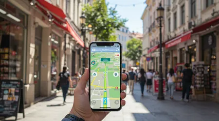
Traditional mapping tools which treat every sidewalk and curb as equally traversable fail to acknowledge the complex realities of accessibility. Fortunately, a technological revolution is unfolding.
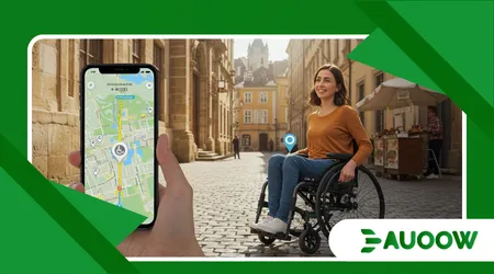
AR Navigation Apps Are Helping Disabled Travelers fundamentally rethink urban exploration. By overlaying critical accessibility data directly onto the real world, these augmented reality tools transform frustrating obstacles into clear, manageable pathways.
This shift leverages cutting-edge spatial computing to move beyond static, two-dimensional maps. We’ll delve into the specific AR features that empower users, from real-time hazard identification to personalized routing.
This technology is not just about convenience; it is a crucial step towards genuine urban inclusion, offering independence and dignity to a historically underserved population.
The Limitations of Legacy Mapping: Why GPS Fails
Standard GPS navigation was built for cars and able-bodied pedestrians, completely ignoring micro-level environmental hazards. This systemic oversight creates significant barriers.
The Curb-Cut Conundrum
A conventional map sees a corner; a disabled traveler sees a potentially impassable curb or the absence of a crucial curb cut. Standard GPS routes do not integrate this micro-data.
For wheelchair users, a missing curb cut means a lengthy, dangerous detour into traffic, rendering the “shortest route” unusable. The map’s perceived efficiency is an actual liability, proving that technology must become contextually aware.
Blind or low-vision users also face dangers from unverified street furniture or poorly placed construction. Traditional maps are essentially useless for this level of detail.
++ Daily Accessibility: What is good contrast ratio WCAG
The Visual Noise and Cognitive Load
For individuals with cognitive disabilities, dense visual information on traditional maps creates sensory overload and decision paralysis. They need simplified, directive information.
AR simplifies the visual field, overlaying only essential directions directly onto the live camera view. This reduced cognitive load makes navigation safer and less stressful, especially in bustling urban environments.
This failure of legacy systems underscores why new solutions are essential. AR Navigation Apps Are Helping Disabled Travelers by filling this critical data void with real-time, validated information.
The Mechanics of Empowerment: AR’s Accessibility Toolkit
Augmented Reality delivers spatial information in a way that is intuitive and instantly actionable, overcoming many traditional navigation challenges.
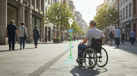
Real-Time Hazard Identification and Path Validation
The most powerful feature of AR navigation is its ability to identify and highlight micro-barriers in real-time. This includes obstacles that appear after a map has been digitized.
Also read: Accessibility Myths Debunked: Separating Fact from Fiction
Virtual Guardrails and Haptic Feedback
AR apps, using the device’s camera and LiDAR (if available), detect temporary obstacles like construction zones, improperly placed scooters, or fallen objects. The app then visually or audibly guides the user around the hazard.
For visually impaired users, the app provides haptic feedback (vibrations) indicating proximity to detected obstacles. This creates a “virtual guardrail” effect, vastly improving safety and confidence.
This active spatial awareness is a massive leap from static maps, which rely on outdated, non-dynamic data. The ability to avoid an unexpected barrier is what truly defines How AR Navigation Apps Are Helping Disabled Travelers.
Read more: Why Sidewalk Design Still Excludes Millions of Disabled People
Slope and Surface Analysis
Many mobility device users struggle with steep inclines or uneven surfaces (cobblestones, gravel). AR apps can process depth and angle data from the camera to provide real-time slope analysis.
The app overlays warnings or color-codes routes (e.g., green for < 3% slope, red for > 6% slope), allowing users to select paths based on their physical limits. This precision allows travelers to manage fatigue and prevent potential injury.
This technological precision provides a layer of personalization that turns an abstract route into a physically achievable journey.
Indoor Positioning and Complex Environments
Urban travel often involves navigating complex indoor spaces airports, train stations, and shopping malls where GPS signals fail. AR thrives in these environments.
Beacons and Visual Simultaneous Localization and Mapping (VSLAM)
Inside large buildings, AR apps utilize pre-placed Bluetooth beacons and VSLAM technology. VSLAM allows the phone to understand its position relative to the surrounding visual environment (walls, pillars) without relying on GPS.
This enables turn-by-turn guidance inside airports to locate an accessible gate or an accessible restroom, areas notoriously difficult to map. The visual instruction is superimposed onto the real environment, providing clear, unmistakable directions even in high-traffic areas.
Example: A visually impaired traveler using an AR app at a major hub like Frankfurt Airport receives audible directions overlaid with spatial cues, guiding them past dynamic queues and directly to the accessible restroom door, indicated by an augmented reality marker.
The Data and The Future: Collaboration for Complete Coverage
The success of AR accessibility is entirely dependent on the quality and depth of the underlying accessibility data.
The Role of Crowd-Sourcing and AI Validation
No single entity can map the entire world’s micro-accessibility data. This necessitates a collaborative approach combining human input with machine learning.
The Accessibility Data Gap
Despite global efforts, a massive accessibility data gap persists. Only a tiny fraction of global urban pathways have been verified for curb cuts, ramp locations, or accessible transit stops. This is the bottleneck for broader AR adoption.
Statistic: A 2024 analysis published by the Global Accessibility Reporting Initiative (GARI) found that in G7 nations, less than 12% of third-party public mapping data includes verified, multi-point accessibility information (like curb heights and ramp gradients). This highlights the sheer scale of the mapping challenge.
| Navigation System | Data Source | Detail Level | Real-Time Awareness |
| Legacy GPS (Google/Apple) | Satellite, Street View, User Reports | Street/Building level; static. | Low (Traffic only) |
| AR Accessibility Apps | LiDAR/Camera, Crowd-sourcing, VSLAM | Micro-level (Curb cuts, slope, temporary obstacles). | High (Real-time detection) |
AI Validation and Data Integrity
AR development relies on AI to validate crowd-sourced data. When multiple users confirm a route is accessible, the AI assigns a high confidence score. Conversely, the AI detects contradictions (e.g., an object appearing where a ramp should be) and flags the area for verification.
This automated validation ensures the data remains current, trustworthy, and actionable. Trust in the information is paramount when a user’s safety or mobility is on the line.
The Path to Inclusion: A Call to Action for Cities
The potential of AR Navigation Apps Are Helping Disabled Travelers hinges on municipal and private sector collaboration. Technology can only be as good as the infrastructure it maps.
Policy and Private Sector Synergy
Cities must stop viewing accessible infrastructure as a niche requirement and start seeing it as a vital layer of public utility, just like lighting or sanitation.
Mandatory Data Sharing
Governments should mandate and standardize the sharing of accessibility data for all newly constructed public infrastructure. This data, which includes precise measurements of ramps and tactile paving, should be immediately ingestible by AR mapping platforms. This policy shift is the quickest way to close the data gap.
Example: The city of Barcelona established an open-data mandate in 2023 requiring all new public works projects to publish accessibility metrics to a standardized API, accelerating local AR development.
The Analogy of the Lighthouse
Consider the AR app as a powerful, personalized lighthouse. For decades, city planners only provided basic coastline maps. Now, the AR lighthouse cuts through the fog of inadequate data, showing the specific safe harbor (the route) to each vessel (the user) based on their specific limitations.
This shift moves from one-size-fits-all planning to personalized, necessary guidance.
Conclusion: Redefining Urban Mobility
The fusion of augmented reality and detailed spatial data is rapidly redefining urban mobility. AR Navigation Apps Are Helping Disabled Travelers move from dependence to independence, transforming the abstract promise of accessibility into a daily reality.
The technology empowers users not just by showing them where to go, but by confirming how they can get there safely and efficiently, one curb cut and ramp at a time.
The future of travel must be one where the map bends to the user’s needs, not the other way around. What steps will your community take today to ensure its accessibility data is ready for this vital AR future?
Share your thoughts on the most crucial accessibility data points needed in the comments below!
Frequently Asked Questions (FAQs)
Q: Does AR navigation require special equipment?
A: Not anymore. Most modern AR navigation features work using the cameras, sensors (like accelerometers and gyroscopes), and increasingly, the LiDAR scanners built into current high-end smartphones (iOS and Android). Dedicated AR glasses are emerging, but the smartphone is the primary tool.
Q: How do AR apps help the blind if they rely on sight?
A: AR apps for the blind rely heavily on non-visual inputs. They use spatial audio (3D sound cues delivered through headphones) and haptic feedback (vibrations indicating direction or proximity to hazards) to convey information.
The app acts as an intelligent auditory assistant, announcing obstacles and directional changes based on real-time camera processing.
Q: What if the AR app is wrong about an obstacle?
A: Accuracy is critical. The best AR Navigation Apps Are Helping Disabled Travelers by continuously using AI and crowd-sourced reporting.
Users can immediately flag an inaccurate curb height or a new obstacle. This dynamic feedback loop is essential to the system’s trustworthiness, ensuring the data is reliable for physical safety.